- Geophysical methods applied to ground water prospecting
- Geology and Hydrogeology
- Mineral Exploration
- Geophysics Applied to the Engineering and Mining
- Underground Water
- Analysis of Soils and Limestone
- Analysis of Water
- Pollution Studies
- Infiltration Determination in Dams
- Studies of Foundations by Geophysical Methods
- Geophysical Mapping for the Determination of Favorable Zones in the Search of Gems
- Studies for Implant of Mineral Industries
- Solicitation of Mineral Research
- Evaluation of Mineral Reserves
- Borehole Geophysical Surveys
Water prospecting:
Good drinking water can be obtained of zones of fractures from hard rock. Water for the industrial and agricultural use same. Drilling without a careful investigation will rarely produce water in economic amounts.
In any program seeking to obtain underground water is necessary to include geophysical and geological investigation.
The wells highly productives are obtained drilling in rock zones that appear along fractures and cavities.
The team of ENGEO has the experience of more than 20 years in the research of underground water in fractured rocks and " Karst " (zones), in the whole country and in the exterior.
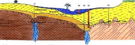
The geophysical methods find geological structures where amounts of underground water can be accumulated and therefore allowing to the drillers the local ones more promising. It is still possible to differentiate fresh water of salted water. The geophysical profile supplies a serie of geological information thus enabling a more precise evaluation of the place to be drilled.
Send us your E-mail or enter in contact with us exposing your water problem. We are leaders in the prospecting of ground water by geophysical methods.
TOMOGRAPHY ELECTRIC A POWERFUL TOOL
JELT4 and VLFRES are two "softwares" using the most advanced scientific principles and methods in mathematics, structural geology and geophysics to locate wells for ground water.
In fact the two programs above, simply maximize the chances of finding economic amounts of water.
It is also a valuable help in the geological mapping of subsurface and in the integration of data with the methods that use the electrical resistivity as measure parameter.
The softwares JELT4 and VLFRES developed by ENGEO using the Eletromagnetic-VLF method allows to obtain a variety of subsurface scenaries to help to buil the best models, reducing thenrisk and finally to find nore water in economic amounts and given more informations on the water quality in terms of salinization.
You can obtain the following informations:
- Horizons of the several layers
- Approximated depyhs of the aquifers.
- Section that shows the geological structures approximately.
- The zones of high and low resistivities
- Allows to infer pseudo curves of electrical resistivity (induced resistivity) for diferent depths.
- The section allows to select curves of electrical resistivity (induced resistivity) for differents depths.
- The section allows to select local for the accomplishment of more electric surveys or the application of another geophysical methods.
- The best locations for the well or wells to be drilled.
- Faults prediction and fractures related.
- Caves preciction and other structures in the Karst.